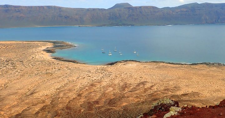
The land was stark. As Oh! approached the anchorage at the south end of Graciosa Island, the only colours we could see were earth tones of sandy beige, brown rocks and steep sandstone cliffs. Other than the blue of the sea and sky, the yachts quietly sitting at anchor provided the only colourful hi-lights. As I stood on the deck of Oh! taking in the barren island in front of us, the colour green simply didn’t exist. Even more surprising was that there were no buildings in view along the beautiful beach front. The only settlement on the island was not visible from where we were, so there weren’t even buildings, or manmade structures within sight to add colour; just sand, gravel and rocks. Once we got to the beach it was clear there was vegetation. However, it was dried grey and brown by the relentless sun – waiting for the next rain. Our introduction to the Canary Islands was like the opening scene of a western movie, sands, gravel, desert dust and dried plants – a desolate and deserted place. We had been told by our friend Sergio who lived on nearby Lanzarote Island that Graciosa was a “very special place”, “very beautiful”. That beauty is in the raw starkness of the almost deserted and arid island. The only settlement is the small village and vacation destination of Caleta de Sebo where some low white, cubist and adobe style buildings are found. Most of the island is protected as part of the Chinijo Archipelago Natural Park and is a draw for tourists seeking sun and almost deserted sandy beaches. The streets are sand and vehicles are not allowed on the island. My first impression of the village was like walking onto the deserted movie set of an American western where the gun fighters are about to step in to the street after everyone had run inside and locked their doors to take cover. However, this set had modern white washed buildings. It was December and the Christmas tourists had not yet arrived while the summer crowd had long ago left – it was a very odd setting, not at all what I had expected to see in the Canary Islands. From our anchorage the village Caleta de Sebo was not visible unless you climbed the flanks of the prominent cinder cone of Montaña Amarilla, at the SW most point of the island. The climb was well worth it, not only for the views but also to appreciate the beauty that Sergio had found so hard to describe.
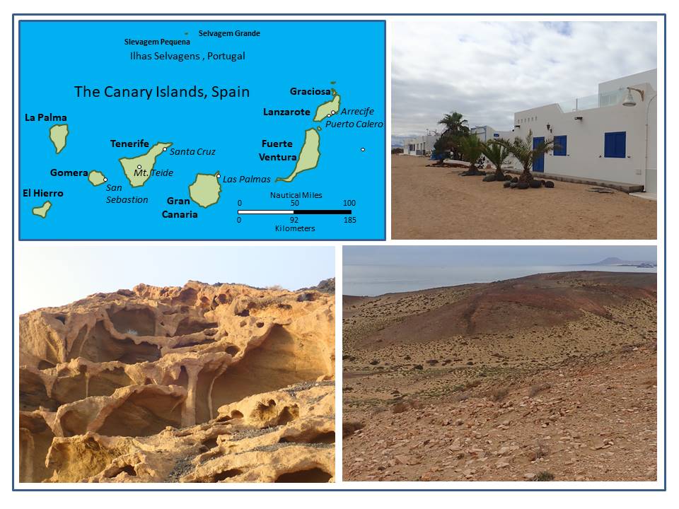
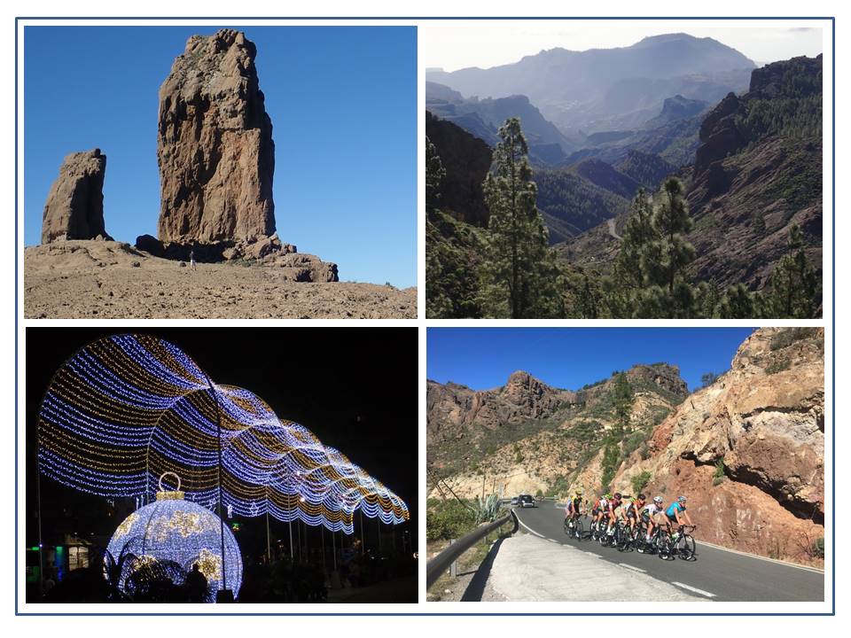
Caption: The Canary Islands are spread over an area that is 250 nmi. east to west and 130 nmi. north to south. The white buildings and sandy lanes of Caleta de Sebo, on Graciosa Island were our introduction to the monotonous architecture of the eastern Canary Islands. The weathered sandstone cliffs on Montaña Amarilla are beautiful examples of the “art of nature”. A picture just does not do them justice. An arid landscape of rocks, gravels and sand make up the majority of Graciosa, Lanzarote and Fuerte Ventura Islands. These islands are a stark contrast to the much higher and greener islands that are located further to the west.
The Canary Islands are one of two large archipelagos off the eastern bulge of Africa. The other is the Cape Verde Islands further south. The Canary Islands are comprised of 7 larger Islands and 6 significant islets. The eastern most point of the archipelago is only 62 miles from Morocco. It is not uncommon to see the eastern skies red with dust blowing from the Sahara. After spending even a small amount of time there, the sails will show a tinge of orange at the seams and edges. As I have experienced throughout my Caribbean and Atlantic circuit, the geography and more specifically the topography of the individual islands has been the single most dominant influence to their settlement and cultural development. Basically – height equals fresh water and fresh water meant the ability to settle and create sustainable communities. The history of settlement and development in the Canary Islands is closely tied to that most essential ingredient to survive – reliable, year round freshwater.
Graciosa, Lanzarote and Fuerte Ventura simply did not have that. The islands are low accumulations of rugged volcanic rocks, gravels and sand that are very arid with little or no natural fresh water. Although it was first settled in the 1400’s, the lack of plentiful fresh water would have made it very difficult to survive on these three arid islands. Based on our observations the cultural development of these islands accelerated dramatically with the introduction of large scale desalination plants and mass tourism. By converting diesel to fresh water, the islands could support large scale tourist development and all those modern white cubic buildings sprang up. These islands are now home to thousands of vacation homes, condominium style vacation developments and resorts; all of which had to adhere to a strict building code and design criteria.
Most of our time was spent on the island of Lanzarote which is dominated by these white cubist style vacation developments. If you like that architectural form you would be in heaven. However, it quickly became very monotonous and overwhelming, for me it was visually numbing. Geologically the island is fascinating with active volcanism just below the surface, recent lava flows, salt ponds, several beautiful beaches and an excellent network of roads to explore the island or trails to walk. The eastern Canary Islands are a great place to enjoy a warm weather vacation, sun, sand, surfing, kiteboarding, cycling; or simply kicking back to get the chill out. We spent a day touring the island of Lanzarote by car and discovered there was a lot more to these dry plies of sand and gravel than first meets the eye. They are very popular with cyclists due to the excellent road network and relatively light traffic. The island offered everything from a dinner cooked using subterranean volcanic heat, to exploring the villages tucked into small fertile valleys or visiting subterranean lava tubes. Plus, there is a lot of public art on display that is always welcome. There is a beautiful pedestrian and cycling promenade at Arrecife that is a wonderful way to enjoy a day out. On the northern end of the island there is a fabulous beach where you can try surfing. It is also a great place to just stroll along in the gentle waves that wash up on the beach while people watching, or taking in the stunning views. There is no surprise as to why this island has become a very popular vacation destination for Europeans. With daily average temperatures of 21-29°C year round and only 110 mm (4.3 in) of cumulative rain spread throughout the year, visitors are almost guaranteed warm dry weather.
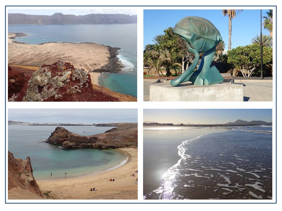
Caption: Looking south over the small anchorage on Graciosa Island from the top of Montaña Amarilla with the sheer cliffs on the NW side of Lanzarote in the background. One of the dozens of interesting and provocative artworks placed along the seaside promenade at Arrecife. The wide sand beach at the NW end of Lanzarote is a perfect place to learn surfing, or just enjoy a day at the shore. The bays at the south end of Lanzarote are well protected from prevailing NE winds and are good anchorages with beautiful beaches and plenty of trails and walks in the surrounding hillsides.
The western and north western shores of Lanzarote are exposed to the North Atlantic and clearly take the full force of Atlantic storms. The coast is essentially all rugged cliffs and sharp rocks. Even on a calm day where we could see very little in the way of ocean swell, massive waves were building and crashing all along the coast – much to the delight of the surfers. The powerful waves would rise up near the shore breaking against the cliffs and sending spray well over 20 meters into the air. It was fun to watch but also a fearsome reminder of what a lee shore can be, even on a calm day. I shudder to think what it would have looked like in storm conditions. During our sightseeing, we discovered blow holes, camel trains and salt farms while surrounded by stunning vistas of the wide variety of volcanic landscapes on the island. The Timanfaya National Park is well known for a massive lava flow that was left from eruptions in 1730 and 1736. The lava flow is rugged and fresh looking with very little vegetation. It does not look like the eruptions occurred almost 300 years ago. Its fresh appearance has been preserved by the arid climate. As a comparison, the last major eruption on the Island of Martinique in the Caribbean was in 1902 only 117 years ago. That devastating eruption of Mt. Pele buried the capital of St. Pierre killing all but one resident. The lava flows from Mt. Pele are now almost completely covered and grown over in lush vegetation to the point that they are no longer readily visible.
After spending just a few days in the eastern Canary Islands I could now fully appreciate just how dry and barren these islands are, but also the unique environments they have. It had also helped me to put in to perspective the comments of a French couple who we had met the year before while in Martinique. They had just arrived from the Canary and Cape Verde Islands and were so excited to see the lush green of the rain forests and colourful tropical vegetation of the Lessor Antilles. Our friend Sergio was correct – these islands are very special and very beautiful, but in a very different way to most of the islands we have visited on our Atlantic Circuit. The eastern Canary Islands with their predictable warm and dry climate would be a perfect spot to escape the cold damp winters of Europe. Clearly we did not have enough time to fully explore all the natural wonders of the eastern Canary Islands, which means there will still be plenty to see when we return.
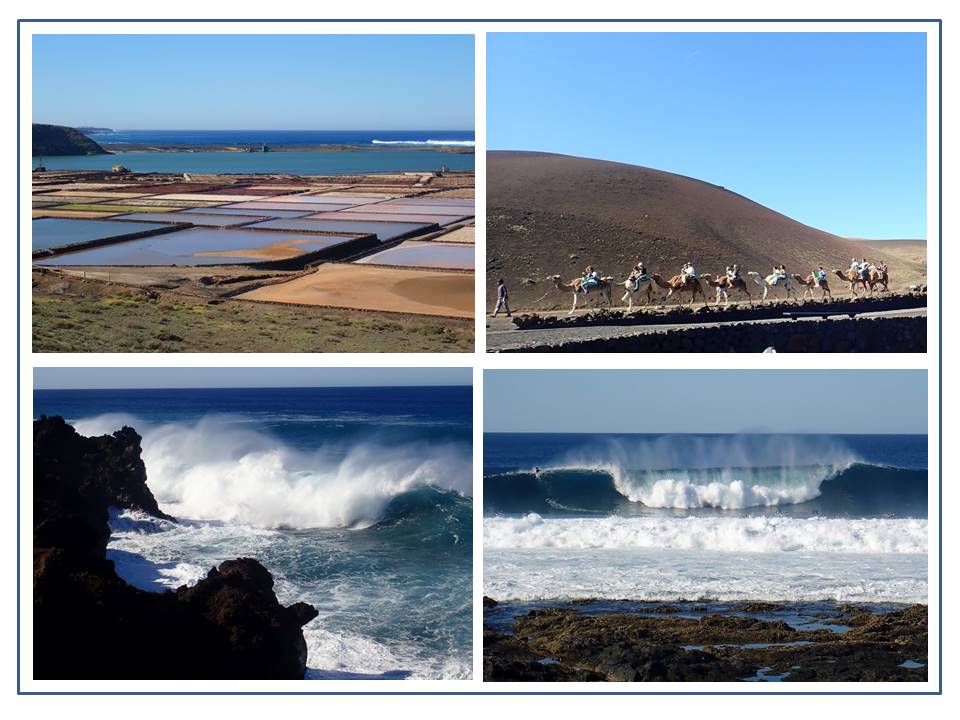
Caption: The Salinas Janubio salt flats on the SW side of Lanzarote. Camels were used extensively in agriculture on Lanzarote and are now an opportunity for tourists to interact with these amazing animals and experience a camel ride. Surfers get a short but exhilarating ride on the big waves; they just have to be careful of that jagged and very sharp volcanic rock shore that lies in front of them. Massive waves at least 5 meters high on a, “very calm day”, rolling and breaking along the north coast of Lanzarote.
From Lanzarote our next stop was Las Palmas on the island of Grand Canarias where we would meet up with our crew that was joining Oh! for the upcoming trans-Atlantic crossing. The plan was to spend a few days provisioning on the islands of Las Palmas and then Tenerife in preparation for the voyage. Both Islands have large marinas, excellent yacht services and a wide variety of provisioning options. They also have excellent flight connections from North America and Europe. However, a note from our Norwegian friends put a small kink in our plans just 3 days before our crew were scheduled to arrive. I had given up on being able to fit in time to climb Mt. Teide which at 3718m ( 12,198’) is the highest point in Spain. Mona and Arno had sent us a note telling us about the fantastic time they had climbing to the summit of Mt Teide and staying at the Altavista Refuge high up on the mountain’s eastern slope so… we were determined to fit into our tight schedule. As luck would have it, there were 5 beds still available a few nights after all of our crew would have arrived. Therefore, we booked two beds and quickly sent a message to the arriving crew telling them of our new plans along with all the information they needed to join us – including packing some winter clothing to come to the tropics! They both jumped at the opportunity to add yet another adventure to their planned adventure of crossing the Atlantic – Oh! Yes!
While on Gran Canarias we had one more day before we had to depart for Tenerife, so our group elected to tour the island by car. That would also give our jet lagged crew a little more time to try to adjust to the 8 hour change in time zones. The island has a rugged and very scenic interior with several small villages that are worth visiting. As we found throughout the Azores, Madeiras and Canary islands, the road network on Gran Canarias was in excellent condition and we frequently passed groups of cyclists enjoying the high mountain passes in the warm sun. There are also many excellent hikes including the walk to the famous Rogue Nublo high in the interior mountains that is also very popular with mountain climbers. The picturesque mountain villages with shops, cafes, markets and restaurants were inviting to explore and helped to balance a day of driving and hiking with time to relax and simply take in the clean mountain air and beauty of the area. We would have liked to have more time to explore Grand Canarias but our Mt. Teide reservations were only 2 days away and we had a good weather forecast for the overnight passage. It would also be a good chance to give our crew a night sail prior to setting out on a 2600 nmi. passage.
Caption: Rogue Nublos sits high on a mountain plateau surrounded on three sides by sheer cliffs – the challenge of climbing its vertical faces is very popular for climbers from all over Europe. The rugged terrain, excellent roads and beautiful scenery are a big attraction for local cyclists. Lights in Las Palama gave the city a festive appearance as we enjoyed several evenings exploring the city’s many pedestrian areas.
As we had found on numerous occasions throughout the Azores and Madeira islands, Mona and Arno had some great information and ideas that they willingly shared. Most people staying at the Altavista Refuge do so to get up really early and climb to the summit in the dark to watch the sun rise. However, that can mean a very crowded summit and a very cold climb. Temperatures on Mt. Teide at that altitude get below freezing levels in December and there is always the potential for inclement weather, or even snow. Mona and Aron recommended arriving at the top of the aerial tram around mid-day then spend the afternoon leisurely exploring the mountain and making the final climb to the summit to watch the sunset if the weather was good. That way there was no early morning rise and rush to the summit with a crowd of others in the cold and dark. The bonus was you got to sleep in! Although… getting up at 7 am is not exactly “sleeping in”. Plus you could still enjoy the sunrise from the deck of the Altavista Refuge since it is located on the eastern side of the volcano. It sounded like a much more relaxed way to see the summit and enjoy the experience, plus it was like getting 2 spectacular settings for the price of 1 – a sunset and sunrise. Oh! and yes – our weather was spectacular!
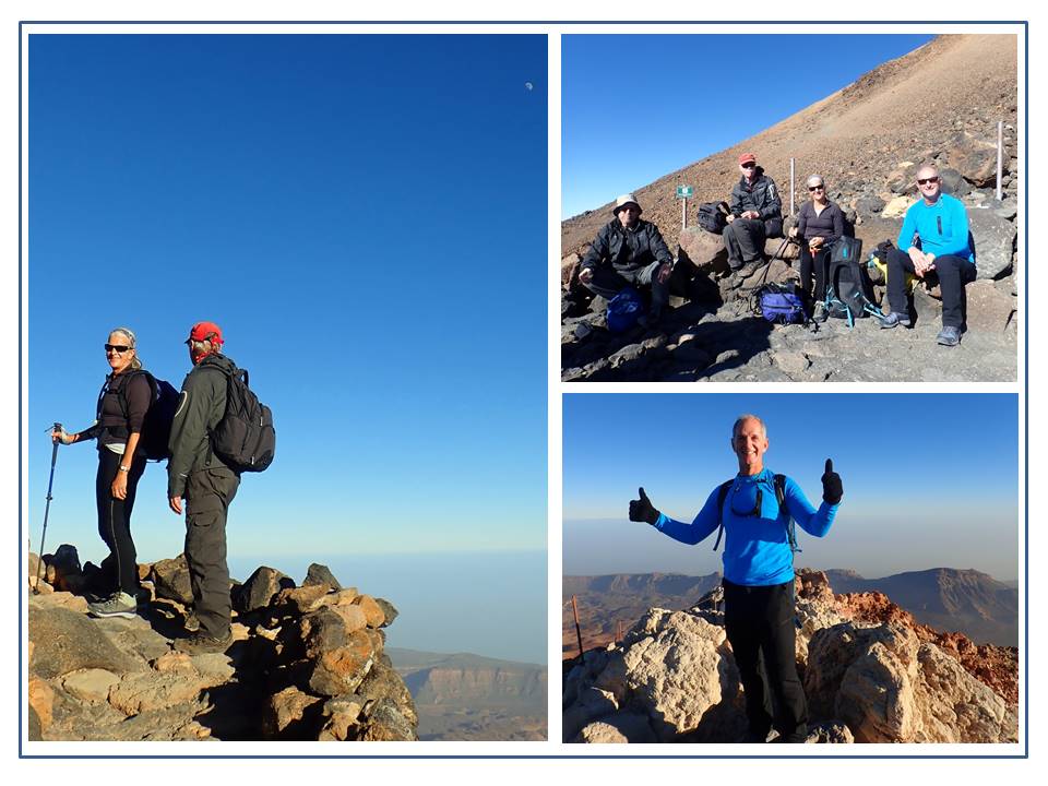
Caption: Climbing Mt. Teide is an easy climb on well-maintained paths, but at that altitude it takes your breath away and not just because of the incredible views! Our 2 new crewmates for the trans-Atlantic passage were fresh off the plane, complete with jet lag and not so tropical attire. Rod celebrating summit number three of the highest points in the Netherlands, Portugal and Spain.
The next morning we were literally the last persons out the door of the refuge as they locked it behind us. The morning was cold and the air was crisp but beautifully clear. Our reward was an incredible sunrise and another day of blue skies and sunshine as our group split up and took two separate routes back to the base. Rob and Steve elected to take the path down, while Diane and I took the path back up to the cable car to enjoy the views while descending in it. However, I think the walk down was probably the better route after comparing our separate experiences. Mission complete – we spent the rest of the day touring the south end of Tenerife before returning late in the day to make final preparations for our departure. Getting to the summit of Mt. Teide meant I had summited the highest points of three European countries; the Netherlands, Portugal and now Spain, each of which was on an island in either the Caribbean or Atlantic and not in the European homelands. It was a fun addition to the long list of adventures we have experienced on Oh!’s Caribbean and Atlantic circuit.
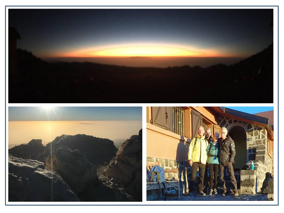
Caption: Sleeping at high altitudes may not give a person a good rest, but the views can be spectacular. The morning was crisp and cold but the sunrise and views were unforgettable as we prepared for the descent.
Our cruising time in the Canary islands had been limited by Oh!’s extended stay in the Azores. That meant that there would not be time to visit all the islands in the Canary archipelago. That was unfortunate because as we moved west through the Canary islands we found they became more diverse and interesting. Unlike the low lying eastern islands of Graciosa, Lanzarote and Fuerte Ventura, that were so dry and monotone in their architecture; the western Canary Islands were much greener. They have more diverse ecosystems, climatic zones and a long history of settlement and larger population bases. The history of larger scale habitation of these islands, plus their physical geography made them much more inviting and interesting. Unfortunately, we had run out of time to visit them. The final island on our abbreviated tour would be a very brief stop at La Gomera. The island is the third smallest of the Canary Islands and is very mountainous with steep slopes and a prominent interior valley. It is well known for the many hiking trails crisscrossing the island and the Garajonay National Park that is now a Unesco World Heritage site. We planned to simply stop for a brief 2-4 hour visit to meet with up with our friend Yoann. He would be making a solo trans-Atlantic crossing at the same time as us. We had met Yoann 8 months earlier in the British Virgin Islands and our paths had crossed many times as we sailed our Atlantic circuit. He would be sailing his beautiful red steel hulled sloop “Saturnin” back to St. Barthelemy where he planned to work. We hoped to have one last visit before our two boats departed. During our many encounters with Yoann we had become good friends and I hoped to meet up with him again in the Caribbean.
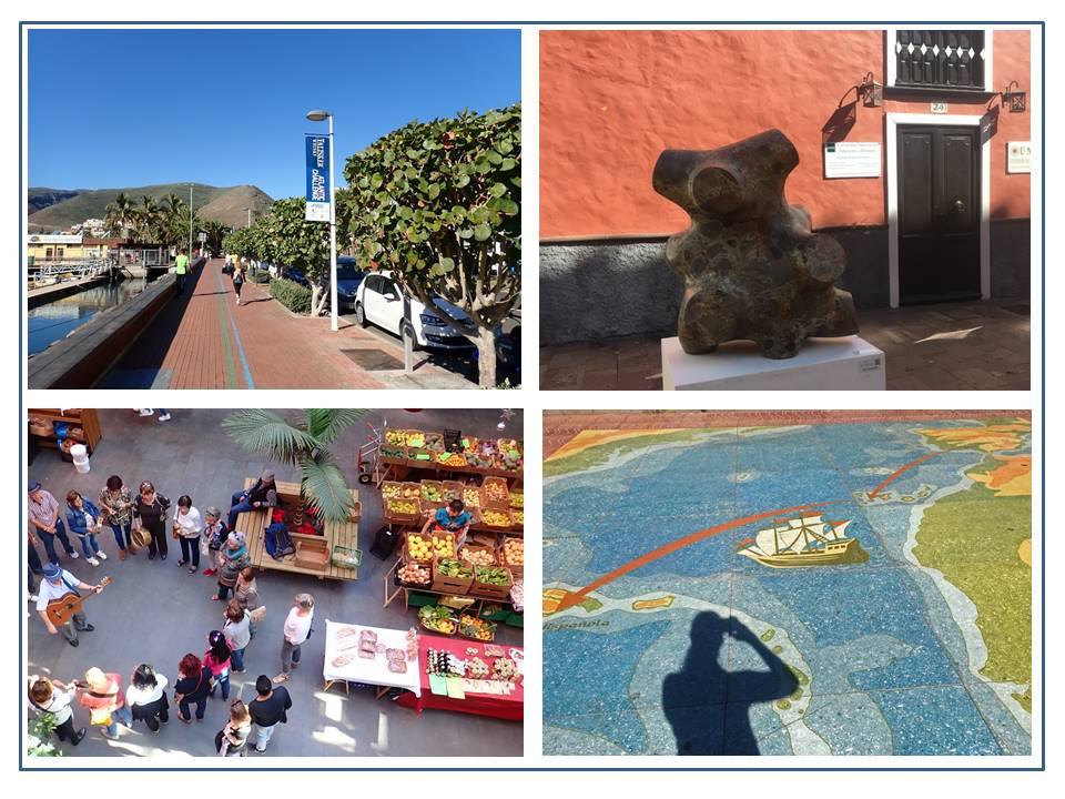
Caption: San Sabastian is beautiful with a waterfront promenade, colorful buildings, art works and celebrated history as the departure point for the discovery of the “New World”. We thoroughly enjoyed the market complete with live music and dancing. Our pending voyage across the Atlantic will start from where Columbus departed.
During our afternoon tour of San Sabastian de la Gomera, we found a beautiful town filled with colorful and interesting buildings, lots of public art, a market with live music and dancers, and spoke with several visitors about the island and its many attractions. La Gomera is the last island Christopher Columbus visited before crossing the Atlantic Ocean on his voyages of discovery between 1492 and 1498. The fertile farm lands of the interior valley made the island a perfect final stop for provisions prior to setting sail into the unknown. What a feeling that must have been for the crews of the Santa Maria, Pinta and Niña to simply sail toward an endless horizon of water – with no knowledge of what lay ahead, or even if they would ever return. Compared to the creature comforts and luxuries of Oh! and the electronic systems, GPS and knowledge we have of weather patterns, currents, distances and accumulated knowledge since that time – crossing the Atlantic seems so incredibly simple now. As we walked the streets and spoke with locals and visitors the idea of spending several weeks just exploring this island grew stronger with each person we met. Just as Columbus’s first stop at San Sebastian grew from a planned single week into more than a month, I really wanted to extend our stay. However, that just wasn’t possible. I am definitely planning to spend a lot more time here when Oh! returns to the Canary Islands in the fall of 2020. Our final port in the Canary Islands would be the same port from which Christopher Columbus set out in 1492. As the evening approached we cast off the dock lines and headed toward the setting sun.
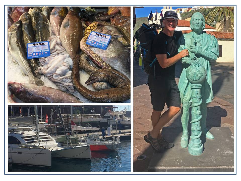
Caption: The fish markets in the Azores offer a wide variety of delicacies from the sea that was an eye opener for a prairie boy like me. Getting tips from Christopher for the upcoming voyage was tough – he was a man of few words! Oh!, my Leopard 40 catamaran dwarfs Yoann’s Saturnin even though there is less than 4 feet difference in length.
This is the last in a planned series of 9 articles written about our Atlantic and Caribbean circuit on Oh!. However, there may be one last leg to chronical – The Atlantic crossing west back to the Caribbean. Check back again soon.